I was pretty nervous about this climb, as I'd never been above 11,500ft before. Another 3,000ft is a big deal and I was concerned about experiencing altitude sickness. I was only invited to join this hike a few days in advance of it happening, as someone else had dropped out of the group. Mt. Whitney has a competitive lottery system for distributing limited numbers of permits, which takes place in the early spring each year, so I was excited to be invited to join in, but felt very unprepared. Thankfully, after days of vacillating, Nikkie talked me into it and it was an amazing and beautiful experience.


Jess, Nikkie, Claudia, Kevin. And then Jess, Nikkie, Claudia, Gary.


Crossing streams in the dark.

That little while dot is a headlamp down there far in the distance. And a lake to the left of the headlamp.


So pretty in the morning light.


Guitar Lake.


Kevin and I were the first two people to reach the summit (around 7am) who had started all the way down at the Whitney Portal. Other people choose to camp out around 10,000ft and start off from there in the early hours of the morning. We started around 8,300ft.

Signing the register.

I had a lot of trouble writing because my hands were numb.

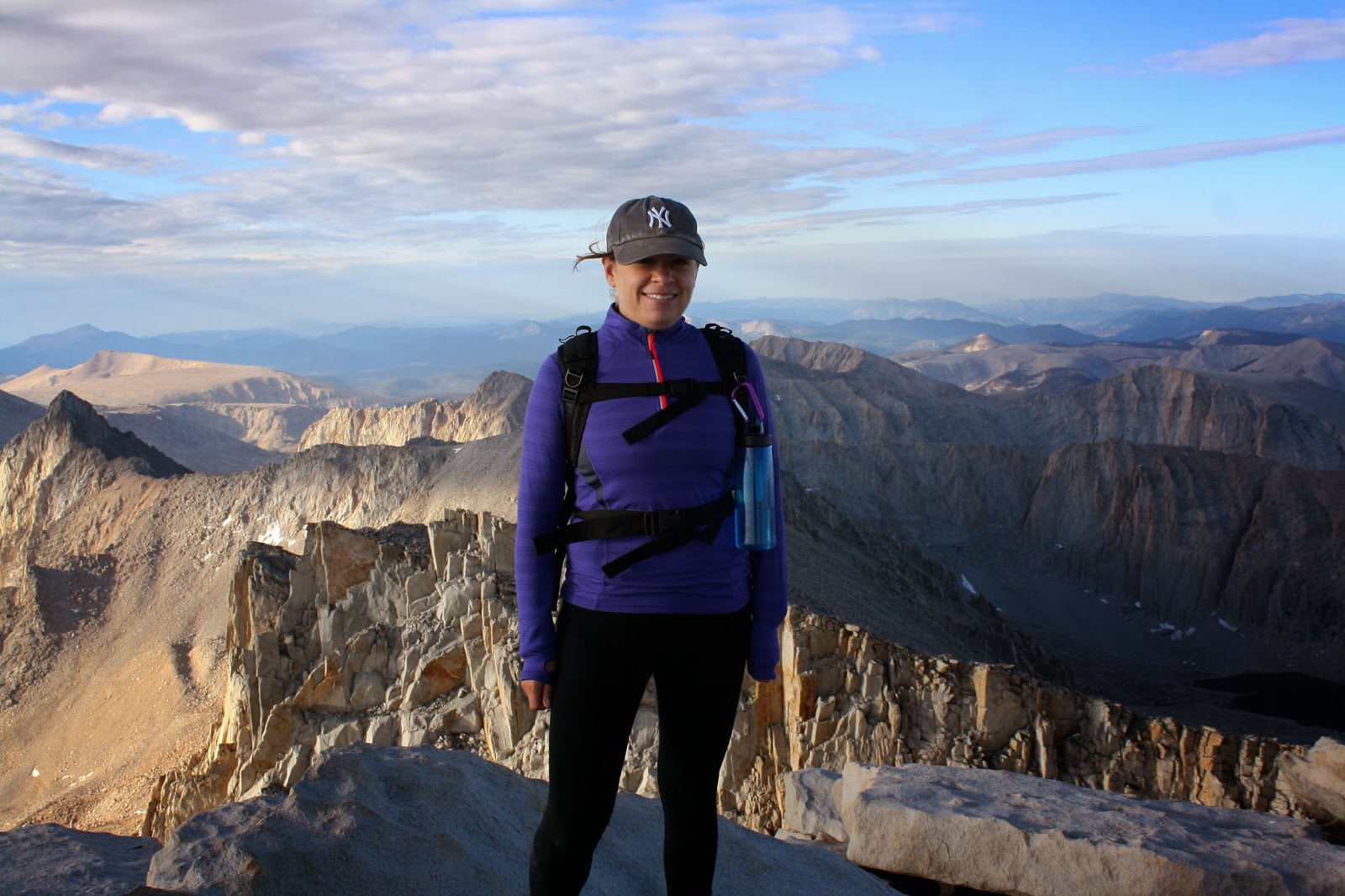
Triumphant!
Thankfully, I did not experience any symptoms of altitude sickness! The only thing I can say for sure is that trying to eat/drink and hike at the same time at higher altitude is much harder. It sort of feels like you're suffocating because the air is so thin that you can't get enough oxygen in the normal breaths that you would take while walking and eating or drinking. Even talking was a bit of a challenge.


I look really uncomfortable in this picture and it is because I am absolutely f***ing freezing.
After this, we ducked into a shelter on top of Mt. Whitney, which started filling up with other people. There were some PCT through-hikers in there, as well as some older men, one of whom was celebrating his birthday. We all drank quite a bit of whiskey and then slowly trickled out into the cold to begin our respective descents.


There was snow and ice in some places. It was really cold, no joke!


Marmot!

Stream crossing.

Water falling.


It did rain a bit.


This is at the beginning of the trail. I don't know what it is. But it's got maps and stuff in it.

Lone Pine is the last town before entering the "Whitney Portal". There was apparently an earthquake in Lone Pine in 1872 in which 52 of 57 buildings were destroyed. This little piece of adobe wall was part of the general store and is the only example that remains of the architecture of the time.

Post-hike beers at the saloon!


Bye y'all!
im a fan of this....very pretty! the mountains and you!
ReplyDelete